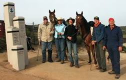
The Mexican Border – We arrived at the Mexican Border early with the full crew on hand to send us off.
 There were approximately 750 attendees at the “Kick Off” of the 2009 season rally with probably 300 or so hikers starting this past weekend. So many people with fresh, energetic enthusiasm to go the whole way to Canada, young college kids, professional career types, those who are caught in a time warp from the 60’s and all the other possible representatives of humanity marching north positive they are going to become members of the elite few “thru hikers class of 2009.” All of us have planned to give up society and it’s comforts for 4 or 5 months for this. There were no other horse starters. For me, I am following a different theme, working towards a partnership with communication skills required to be able to understand Port’s subtle mannerisms and being able to act on those before we both have problems. This is not an endurance test, but a way to have the ultimate horse experience, bonding and getting to know another species so no language communicating is necessary. So we are the anomaly, the only horse people, the only ones looking for some intangible goal only horse lovers understand. Port’s big kind eye says he is ready.
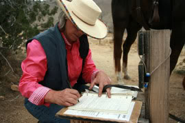
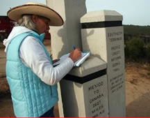
At the inception, the elevation starts at 2900’ and I sign in the log book hidden in the monument
 thinking about how many times I hope to do the same thing along the 2650 miles and relish in the feeling of a new adventure. We walk away from our support crew who will work towards our goal along with us, pulling the trailer north and meeting us with our necessary supplies…this trip would be very difficult if they weren’t in the back ground. I originally had planned to cache my supplies (bury them at expected 5 day intervals along the major roads where I have to cross) and not have a support crew but my entire family was just too concerned and the nature of this kind of trip is stressful enough on loved ones so I made concessions. Good thing my family is sensible!
 The trail is sandy with great footing, only an occasional rock to walk around. I notice Port is feeling good but cautious and not really interested in moving away from the trailer. He has already understood that it is his home and looks back hoping I might just return. We get no further than a mile
 and I have to question the trail location. So many people have come to see loved ones off that the shoe prints go in every direction. Oh well, I’ll get good at navigation along the way, (or not!) The grade is easy and I think this is “no problem” completely denying the maps and the confirmed elevation increase. We travel along some ridges and overlook the town of Campo when I realize I didn’t have my crupper on. So thanks to the modern society that I am shunning, I call Burton on my cell and ask him to wait so I can climb down the mountainside and pull the crupper out of the bowels of the trailer. Janice holds Port and I scale the rocks and walk down the road to the trailer visible at the feed store. Uh, Susan, things look a lot closer than they are and I walk a very long way to retrieve it and then look back up the mountain and realize I have to somehow climb back up those huge boulders to Janice and Port. I better get a grip on my capabilities pretty quick! Anyway, I claw and pull myself back up not disturbing any snakes or other inhabitants to find Port munching on what looks to me to be some type of holly tree and my memory vaguely has a red alert attached to holly trees…I think they are poisonous to horses…..better find out about the poisonous plants along the way. Anyway, Janice says he had just grabbed a leaf or two when I got there. Let’s hope so. We cross several creeklets and one has water. I think this is going to be easy, water, some grass to grab along the way, pretty good footing and great weather. We pull off the side of the mountain and travel 14 or 15 miles. Then it starts…….surely that tiny little path clinging along side of the mountain across the canyon isn’t our trail? Uh, yes it is! From Hauser Creek at 2300 feet in less than a mile to the top of High Point at 3500’ we work our way up. I am off of Port because I just don’t want to sour him with such a hard workout this quick. Now if my heart holds out we should make it to the top of High Point. My lungs feel like they will explode, my legs shake and my heart races, what have I gotten myself into? This darn trail is so narrow that Port looks like he is tight rope walking. I struggle with my fear of heights, telling myself that if I fall maybe I could just flip on my stomach and try to claw into the earth to slow my fall. Get that out of my mind…I AM NOT GOING TO FALL. Oh, good grief I better pay attention and focus on our steps. Lord, I’m scared. None of my research told of people falling on the first day out…Yes, many have died in the Sierra Mountain area and recently 2 women fell to their deaths in Washington at different times but at the same location, but, no record of anyone dropping off this. Get it together, Sue….don’t want to go down in the history of the PCT as the first. I shake as I write this…this is no joke, this is pretty serious stuff with the real challenges mile ahead. My optimism needs a reality check. But, we do get to the top taking the necessary rest to allow my heart (and psyche) to recover. We move on to view the almost dry Lake Morena and I scold myself for being such a woos. We make it to our first camp with the crews there to help us slowly acclimate to camping life. A few hikers make camp there as well and we meet Mark, a young college grad taking a sojourn prior to entering the real world as a project manager. I am sure Mark is destined to be a 2009 elite thru hiker, he just has all the qualities. Hopefully, he will enter our lives again over the next few months.
April 28
Today our goal is Burnt Rancheria Campground, I know they don’t allow horses but I had planned to remote camp at Morris Meadow 3 miles lower but since the support crew is able to stay with us for a while they can find a place to camp. This elevation goes to 6000’ and now I am stressing about ledge riding (or rather ledge walking since I just can’t add the height of Port to my visual dilemma.) But, as we ride on I become engrossed with the scenery with vistas for untold miles. 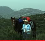 This is truly God’s country. So very beautiful. We travel along the trail going up and down finally going under Interstate 8 and pass along dry creek beds enjoying the ease of passage. We stop for lunch at Kitchen Creek where the crew pulled the rigs for an afternoon siesta. They even set our portable pens to let the horses graze freely for an hour or so. How fortunate I am. We head out and travel until we get to Long Canyon. The horses now are very thirsty and they change pace.
 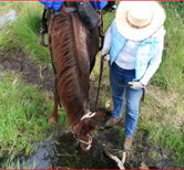 Janice and I notice they are practically pulling us. Then I hear the reason, a small creek is bubbling below coming out of the blind canyon and lined with trees. Such a lovely place to camp. The creek is too far down a steep incline for the horses so we have to scramble down the bank to it hoping we don’t upset the resident snakes. The vines and thorns tangle us as we try to get the buckets in the small pool with a little waterfall above. Then we try to climb back up with canvas buckets full for the horses and they do drink. Yes, another trip down to the creek and back up again. They drink almost all this again. A hiker shows up and said asks where we got the water….pointing down the bank we said it isn’t as bad as it looks…I don’t think this hiker is very thirsty because he hesitates and whines about the thorns and vines….No, I don’t believe he is Elite Quality, my money is not on him. ( Note: 2 years later I crossed paths again with this hiker - "Gourmet" and he was fit and looked like a premier distance hiker if there ever was one.) We head out and travel along Long Canyon for several miles, delighting in the scenic creek, lined with trees and rolling grass fields to it. If our crew wasn’t waiting for us up on Mount Laguna I would have stayed here for a night just to enjoy it. So on we go finally catching up with a very tired and dismayed looking hiker about my age. He said he wanted to make it to Morris Meadow but I know he didn’t realize that was almost 3 more miles and all up. He looked desperate. So, I offered to put his pack on Port saying I would drop it off for him at the meadow. He thanked me in disbelief and introduced himself as Cottonmouth Bill (the trail hikers name each other and my name is….guess what? “Grayhair” good grief!) So with Port loaded with an extra 40 pounds I am walking again. Janice and I move out but try to keep an eye on Bill who is awfully slow and stumbling. I call to Janice and tell her that Bill is in worse shape than we thought. We decide to get Bill to grab Janice’s horse’s tail and allow Jur to pull Bill up the mountain. Jur leans into it like a pro and I watch them as Bill stumbled along holding steadfast to Jur’s tail. Finally after having to slow our pace to accommodate Bill we get to Morris Meadow. Bill looked like he might collapse but was revived when he saw a cache of water bottles placed for the hikers by some kind soul ( usually called trail angels) and decided to camp right there. Knowing Cottonmouth Bill was safe we trudged on to meet the trailers. Three hours later we finally got to camp. (Note about Cottonmouth Bill - through email Bill told me he had two knee replacements right after this incident but is doing fine and I think I read where he is back on the trail again - no wonder he was having trouble making it to Morris Meadow! 12/09)
April 29,
Today started out uneventfully and we climbed slightly out of the Laguna Mountains 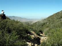 to get to Pioneer Mail Trailhead and then on to Sunrise Trailhead. I am ill at ease because of the poor water quality along the trail and I mistook Garnet Peak for Garnet Mountain missing the oasis spring along the way. Port is beyond thirsty and the realization that a person could die from thirst set in. I know my GPS and my personal satellite locator would save us at the push of a button but to have been so distracted that I missed the closest water was serious.
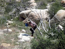 Climbing north and just south of Kwaymii Point is Pioneer Mail. This trail stop will stand out forever as the one where water was available, but only if you could stand ingesting water which had dead animals in it, including rats, squirrels and some unrecognizable water bloated body parts. The water was thick and honey colored and even if Port had wanted to drink it I would have never allowed him to. We moved on to Sunrise Trailhead dropping from 5250 feet to 5050 feet at the water tank. This water stop was established by the California Riding & Hiking Group and the tank was clear enough for me to consider it potable with nice pens and vault toilets giving the trailhead a sense of civility. Here we could rest with Port safely in a pen. Although the sun beat down unmercifully, we did just that.
April 30
The goal today was to get to Scissors Crossing at the western edge of the Anza Borrego Desert State Park. 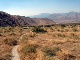 This is also the location of the Old Overland Stage Route where Butterfield stagecoaches carried 9 passengers and 600 pounds of mail, packages and newspapers to San Francisco from Missouri. The desert badlands is anything but "bad lands", with flora and life seeping from every crevice at every shaded turn.
 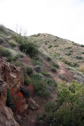 The brilliance of the flowers against the quartz boulders contrasts the unexpected life which lingers here until the sun burns everything back into hibernation in late May. The Manzanita trees drew my attention with their smooth bark which begged to be felt. It reminds me of a rich mahogany with it’s depth and sheen. Enjoying this lovely tree with its ornate angles bending and twisting around split rows of smooth luxurious bark, caused me to become distracted from guarding my way along the trail. Port seemed slightly tender footed so I substituted the light boots he has worn up to now for a set of heavier ones to protect him from the endless number of sharp rocks. Still, Port seemed less than energetic and I decided to walk,
 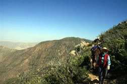 leading him through the rockiest sections. We had a long day scheduled today - 24.6 miles - and I walked most of it, hoping that Port’s feet would heal some. As we came along Chariot Canyon a couple of hikers were talking excitedly and were all concerned with something on the ground. A rattle snake was defending his ground, which happens to be our trail along a narrow ledge with a lengthy drop off. One brave soul used his walking sticks to try to push the snake away and only riled old rattler even more. I have to say I thought the grand fellow was pretty impressive.
He was about as big as my arm, a golden color and had a violent rattle which vocalized his annoyance at our intrusion to his sunning. Finally, the last stand snake gave up his territory and I could feel the machismo blowing in the wind as the hikers told us it was clear to pass. I believe the snake would have struck out and bitten, but it looked to me as if it was scared. He, too, had his back against the wall. We trudged on and at mile 20 I was pretty tired (actually exhausted). I climbed aboard Port, only to find him with even less pace. I jumped off and started to wonder if this entire trip could be over so soon.
I took a chance going against convention and took a bare footed horse into some of God’s roughest country. 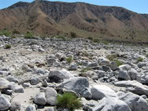 Every traditional horseman told me it was a mistake. But those of you who know me know I don’t give up any easier than that old golden snake. I believe in bare foot horses provided you give the hoof time to acclimate and provide protection when needed. Port started this journey with rock hard feet, capable of crushing Arkansas rocks and doing it at a fine clip for miles. But, we are here, in the Anza Borrego Desert with it’s own kind of horse laming terrain.
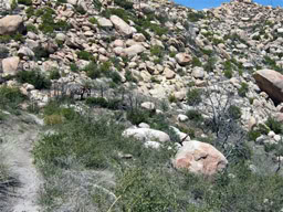 Yes, metal shoes might have served him better on this day, but what about 3 weeks from now when we needed new shoes. And then 3 weeks from then and so on? We could wear out a set of shoes in 200 miles. Port has only so much wall to place holes into.
My confidence has now truly been shaken. Port’s powerful, wonderful stride was short and choppy. The only thing left to do was get to camp and regroup. Exhausted and feeling defeated, I led him the final 4 miles in and pulled his boots off. To my dismay Port's heels were red. Thankfully they did not palpate sore. Maybe in the morning I can decide what to do. The trail ends at a water cache where all the hikers can refill their water bottles. There is also a log to sign in and make comments. In the comment section I complimented the trail crew for their efforts to keep the trail in good condition. I then signed in “Grayhair and Port”