September 16
After a good night’s sleep, I woke up thinking Burton could ride Issy out to the downed trees and help me saw and remove them. Burton was anxious to see the trail so we saddled up;

Shanty and I walked. The miles flew by with me enjoying the river and Burton’s company.

Burton and I had enjoyed the views together only a few times during the early months and that made this trip together even more special.

Issy just packed Burton as if nothing was different, being careful at the ledges and snatching grass when it was available.
Shanty tried to catch the pikas (rounded ear, large hamster like ground animal related to rabbits) but never could find where they disappeared into the rocks. They were too quick for me to photograph mostly because I was so entertained by the chase. By noon we had the trees cleared  and were both enjoying the scenery but concerned that there was a storm over Azurite Peak.

We quickly headed back toward camp encountering a couple of hunters who came up from the river alarming only Burton, Shanty and I since Issy already knew they were there.
These hunters were garbed in the heavy duty hunter’s attire with face masks and rifles packed high above their heads. They frightened me and I was glad for Burton’s company. Issy pulled away from them with a quickened pace, and I kept up, not wanting to be back with the hunters. We crossed the bridge at Rattlesnake River in short order.

It was clear that Burton’s back was hurting. He said little until he finally had to dismount to relieve the strain. By then we were just 2 miles from camp, and Burton & I walked the level terrain cooling out Issy as we went.

September 18
I was up and riding out by 7. I knew we had a pretty good climb and 27 miles ahead of us. The first 10 miles was the Methow River trail which was just as enjoyable as it was the other two times I was along it.
By following Brush Creek we hit the PCT east of Azurite Peak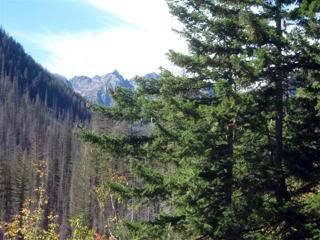
and switch backed up to Glacier Pass.
Issy was all business and I rarely felt the need to walk because of elevation or grade. His powerful gait assured me with every step that he was attentive to the trail and he looked forward and moved with businesslike precision. How I have grown to love riding this horse. His expressive grunts and huffs only amusing me more now that I understand him. He was fit and in great flesh, his feet had gotten hard as rocks and he really enjoys his work. Lucky for me that Mike McEachern (Tb race track trainer) felt Issy would not make a competitive race horse but would not disappoint me as a riding horse. How right Mike was!
I didn’t even know I had arrived at Glacier Pass until I saw a sign on a tree announcing it. 
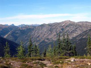
We had gone from roughly 2,000’ to 5520’ in just a few hours, covering 14 miles as if we were strolling in a park. Issy wasn’t even sweating. I was able to photograph an alpine lake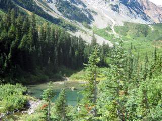
and the most remarkable avalanche chute I have ever seen. The power of the avalanche had ripped the trees into pieces, almost leveling the chute down to the valley. 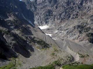
This display of nature’s power was unbelievable. I knew that there would be no escape for anyone caught in such a slide.
Again the scenery, especially the view of Mount Ballard here in Pasayten Wilderness, made me emotional. 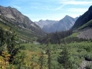
Mount Ballard had snow covered gorges 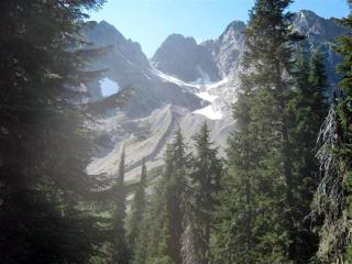
and cast a big shadow over the expansive canyons below. 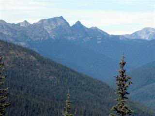
I am not articulate enough to do justice to this indescribable beauty. 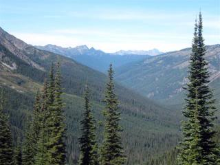
We gained more elevation and at 6750’ we were rewarded with an Alpine garden pass overlooking South Fork Trout Creek. I soon found a wonderful camping area with water just off the crest of the trail. We then traveled on one of those treads where I used to dismount and lead Issy, but no more. 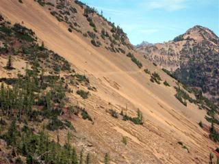
Even though the trail was a mere hint of a trail and we passed along the shoulder of Tatie Peak with nothing but “down” guarding us on the south side Issy marched purposely and with care right along the nonexistent tread. 
We arrived at a pass with more indescribable views.. I grabbed a few photos wishing I had a better camera. 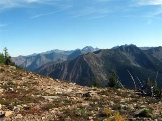
We pulled off the trail to catch Road 500, which leads to Meadows Campground where there was graze and water. Burton met us before we get off the trail. He told me he picked out a camp site 2 miles up on Hart’s Pass, and warned that there was snow again. Hikers had congregated everywhere hoping that the temperature will warm tomorrow so they can make the last 30 miles to Canada without too much snow. I had my doubts. 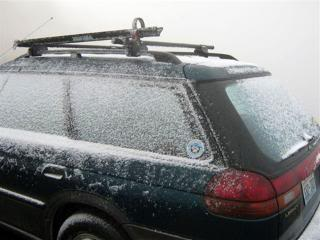
We all tucked away for the night; Issy blanketed in his heavy blanket and Shanty, Burton and I under a tarp strung off the bed of the truck (Burton announced that he will never spend another night in the cab of the truck.) And it snowed.
September 19
We got up only to find the snow had increased. Burton and I drove up to Slate’s Peak where we parked at a trailhead. The snow was worse at that elevation (7,440’) and visibility was zero.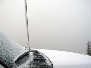
I snapped a few photos and told Burton I was not taking Issy out in that but maybe I could hike to Canada – it was only 30 miles and I could walk that easily.
I had a small back pack in the truck so we went to see if I could carry enough supplies for a 2 day trip. Well, that wasn’t to be. My broken collar bones hurt so much that I could barely get the loaded pack off soon enough.
With no end to the snow, I saddled up Issy and headed back down that treacherous Road 5400. Truly disillusioned, I knew that I would not take the chance with Issy in the snow.

My mission to get to Canada was important but not at the risk of Issy. Actually, when I thought about it, Issy’s safety was the only thing that could keep me from going.
We got back to River Bend covering the 10 miles in only 2 hours since Issy now knew where the trailer was and that he had his makeshift stall with almost all the comforts of home waiting.

It was raining at this elevation (1,800’) so I knew that the snow was mounting back up at Hart’s Pass. It continued to rain on and off for the rest of the day but the temperature was not too bad being in the 40’s. This gave me time to look over the area maps to see if I could get to Canada any other way and it didn’t look good. We would have to get to the Forest Service or speak with the packer again to see if any of the other trails were okay for horses.
Just as I started to load up our stuff a ranger pulled up. Virginia had the answer: drive to Andrew’s Creek Trail and follow the packers trail to Canada there. 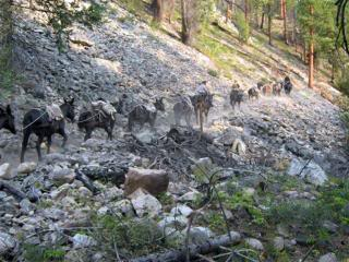
She said the elevation would not get above 7,000’ so we should be okay snow wise and she knew the packers had the trail open because they were taking hunters in and out that way. I was ecstatic! Tomorrow we would head to Andrew’s Creek.
September 20
We drove out of River Bend at noon and stopped at Mazama to buy the copies of the “Green Trails Maps” recommended by the ranger and I quickly found Andrews Creek and the trailhead.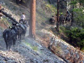
We would have to circle around Robinson Mountain, past Billy Goat Mountain and go through Winthrop then back along the Chewuch River north to Andrews Creek. We arrived at the trailhead at 5 and found a corral sheltered by a canyon wall and graze in the canyon bowl.
This was a perfect camping spot, safe enough for Issy to be turned loose with no hobbles to graze. We all were delighted with our location except for the canyon wall which was all rock everything was perfect. Even the weather was better, although cold there was no sign of rain or snow. A packer came off the mountain right when I was walking to the river to get Issy water so I was able to confirm that the trail was suitable for horses and that it did indeed go to Canada if I got on the right trail.
Great, tomorrow I will ride out 10 to 15 miles and check out the trail.
September 21
I rode up the rock wall and out 15 miles struggling with which trail was which. 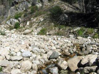
All the trails were very worn and a fire had burned the first 10 miles including the signs. 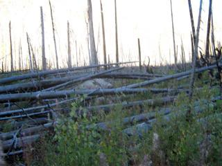
But I knew I was heading north and that would bring me to Canada sooner or later so I enjoyed riding below Wellie Peak and then following along the ridge towards Andrew’s Pass. Tomorrow I will pack my tent and head to Canada.
September 22
Getting up and riding out of the canyon by 7 left me enough time to be absolutely freezing since the sun couldn’t reach into the gorge until around 9. I almost turned around I was so cold, but I knew that if I could just hold out until the sun peaked between the mountains I would be okay. I had plenty of warm clothes in my saddle bags, but to stop and put them on would mean dismounting and losing lots of time. Issy was strong and pulling up the trail with his usual power. 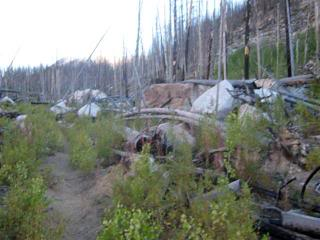
My GPS was loaded and I knew I would get to Canada today. I just had to find the correct trails. The packer told me to follow the mule prints….Maybe he hadn’t looked at the intersecting trails recently but all the trails had mule prints.
No problem, however, my GPS was very clear.
At 15 miles we got to Andrew’s Pass and then the Spanish Cabin (named after Spanish Creek) right where the ranger said they would be. 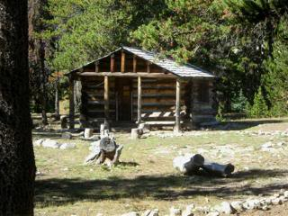
I felt like I was going to make it. Then I got to a 5 way trail intersection. I needed the Boundary Trail, and there was a sign pointing the direction to it but it wasn’t clear which trail to take. I opted for the one which headed “North” but after 4 miles I realized I was at the base of Cathedral Peak and not on the Boundary Trail. 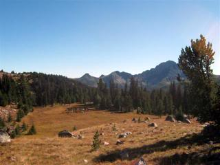
The Boundary Trail intersected with the Pacific Crest Trail to the west and had a couple of smaller trails going north to Canada so I had to go back and try to find it. But, this section of the Pasayten Wilderness was stunning and with Cathedral Peak and Lower Cathedral Lake holding my attention I just couldn’t turn Issy around. 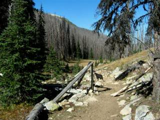
I was drawn forward by such remarkable beauty that few have or will ever see. The mountain tundra was pristine with the narrow trail delicately weaving along the walls and lakes below on both sides. 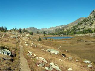
I lost my sense of distance. 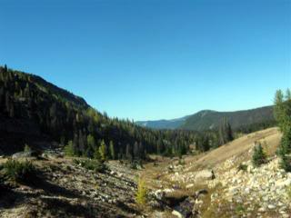
When I realized I better head back I found I was 7 miles off track. I never found the packer’s camp which was on the correct trail to Canada, so with my disappointment mounting I headed back to the Spanish Cabin to start another search from there. By this time I had to decide if I was going to spend the night at the cabin and search again tomorrow, or go all the way back to Andrew’s Creek and get better directions from the packer. I had no guarantee I would find The Boundary Trail if I did stay, and the 24 miles from Burton and the Andrew’s Creek trailhead was all downhill, so I opted to go back to the trailer. Issy was still strong and I knew I could walk if he started to get fatigued.
Predictably, Issy loved the direction change and picked up his momentum. I even allowed him to canter but the packs bounced and worried me. I wanted to get past the narrow, rocky ledge before it got dark but we were too late.
By now I could barely see the ground so I jumped off and turned on my flashlight, but that was a bad decision. The flashlight enabled me to see, but Issy became blinded by it. He rarely ever stumbled but with the flashlight on he was tripping over everything. I had to trust Issy and this time it was serious trust. I turned off the flash light and mounted up. All the stumbling stopped and sure footed Issy was back pulling me forward.
Only once when he started to go on the cliff side of a large boulder did I have to correct his line of travel, otherwise Issy carried me along the trail as if it was daylight.
At 9:30 PM we spotted the trailer lights in the canyon below, and we just had to climb down the rock wall. I dismounted and Issy grunted. I guessed he was disturbed because I would walk so much slower than he would, but I stumbled and leaned on Issy and we finally got back after 48 miles. I quickly unpacked Issy and turned him loose in his corral. He promptly rolled, got up and shook and then cantered around the corral stopping only to smell the other horse droppings. 48 miles and he still wanted to play and canter!
September 23
Last night the area packer told Burton that I was invited to ride with them back to their camp and they would point me in the direction of the trail to the Canadian border. But, Burton told him I had already left. When I arrived, Burton told me I could still catch them at 8 in the morning since they had to climb the canyon wall just outside our camp. I knew that I would never ask Issy to take me back after such a long day yesterday, and I didn’t have to worry because Issy’s fetlocks were swollen all the way around.
This was exactly the same as they were when I left the splint boots on overnight, but of course I hadn’t left them on this time. I trotted him around and he was sound so I decided that the splint boots must have been restricting. I felt he really needed the leg protection from all the rocks so I was very faithful about putting them on along with his hoof boots. I was forced to give Issy a day or more off to be sure nothing more serious was happening to him. The packer with his train of mules stopped by and offered to mark the correct trail with a few flags so when I did get there I could go directly to Canada and not tour and search. By noon Issy’s legs were normal and I decided that the extra protection just wasn’t worth it and tomorrow we would head out again for Canada. Issy cantered and played all day, never seeming to need a rest.
September 24, 25
Canada and the illusive Canadian border tormented me the past two weeks. But, TODAY would be the day, I hoped! Issy was at the gate of the corral, pushing and pawing. I guess he was anxious to head out. By 7 we climbed out of the canyon and crossed the rock bottom creek which fed down to the Chewuch River and quickly were back in the wilderness. 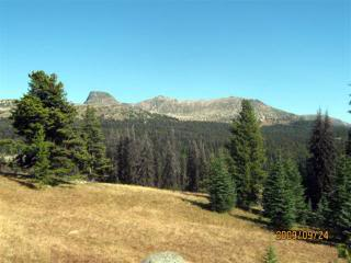
We traversed through the 10 miles of burnt forest not taking any more pictures, pressed on only stopping for a quick drink from one of the many creeklets. Just south of Andrew’s Pass at 6,700’ we met the packer with his whole string of heavily laden mules.
He had broken down his Border Ridge camp so he could move it to a different hunting area and told me that he flagged some of the intersections for a few miles north.
He warned me about a downed tree but that he was able to drop off the ridge and get by it. Other than that he felt it would be clear sailing to Canada. We got to the Spanish Cabin
and found I was supposed to follow along side of it rather than going north as I had done a few days ago. 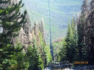
We crossed crystal clear Spanish Creek and climbed to 6,900’ following a trail which I never suspected as the correct one since the tread was neither maintained nor evident. Thank goodness for the orange flags left by the packer.
We circled around and I could see Cathedral Peak in the distance off to the east but still headed northwest.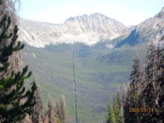
We soon came up to the packer’s camp with firewood still piled up close to the fire ring and wooden tent poles leaning against a tree.
I dismounted and unpacked Issy taking off everything I thought we could do without so we could make a mad dash for the border which was supposed to be about 3 miles farther. With just saddle and waist pack we hurried north quickly getting to the downed tree the packer described. We dropped off the ridge and passed under the tree with Issy barely able to fit under it. We came to a big meadow 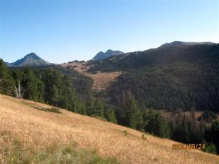
which the packer had described, looked for the tree line we were to head towards and Issy munched his way across. It was already 2:30 and I became worried that we would have to head back soon so we weren’t traveling in the dark. But, I was determined that Canada would not elude me again! I urged Issy on and he responded with a ground covering canter. This time I could enjoy it since we were light and didn’t have any packs. We cantered until the trail became eroded and deep with low, overhanging trees.
I checked my GPS and Canada was just a couple of miles farther so I sent a Spot message to mark my location and pressed on. My Spot must have used up the last of it’s battery to send the message because it just went out. But, I was only slightly concerned. Surely, after having gotten this far I wouldn’t need it again until I got back to camp where I had more batteries, would I?
Then my GPS started to warn that its batteries were going out…. The curse of the Canadian border was pulling out all stops to discourage me from succeeding. I took one last look at my location and turned off the GPS so I would have a little battery left to find my way back to camp. The forest got thick and low and I jumped off Issy moving on at a brisk walk. We came to a clearing 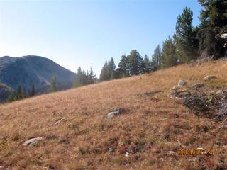
as described by the packer and I thought we were at the border. But, I didn’t feel like it was right so I went on for another mile. And, there IT was…a clearing bulldozed going east and west as far as I could see. At the advice of the packer I headed west. Within 30 minutes I saw the border monument up on the hill. 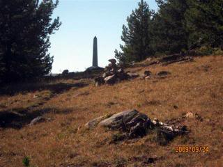
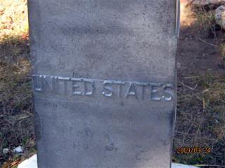
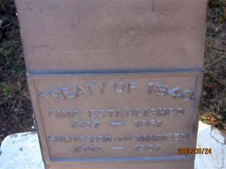
Monument 93
was my reward for all the effort and I tried to take some pictures. Both Issy 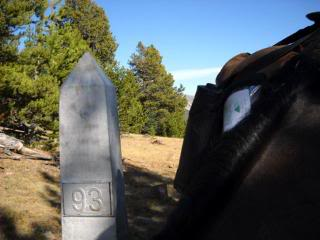
and Shanty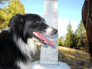
were acting odd and spooky, so I thought it best to snap a few shots and get back on the trail towards camp. 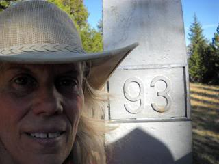
It was already 3:45 and camp was a long way off. The trip back was confusing since I didn’t want to turn on my GPS to confirm my route. Both Shanty and Issy seemed to know that we were heading correctly, and I felt that I could trust Issy’s sense of where camp was. Although the trail looked so very different, I relied on him. My concern that I had to get safely back to camp overshadowed the fact that we had gotten to the Canadian border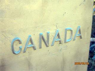
and that the Mexican border was 2,700 miles to the south.
When I recognized the area and knew camp was close, I started to contemplate this victory and magnitude of it all. By 6:00 we drew into camp. I tied Issy to a tree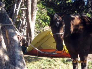
where many horses had been tied before. He seemed to relax surrounded by the signs of others. I set up my tent right on the foot print where the packer’s tent had been the night before. 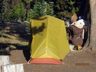 I fed Issy, put some water in my freeze dried dinner, ate it and fed Shanty the leftovers. Dark came quickly but the night was clear with hundreds of stars out.
The temperature was very cold and there were a few snow flakes but the sky was so clear I felt that snow wasn’t going to be a concern. With Issy all blanketed up, I let Shanty into my tent and she crawled up next to my feet. FINALLY, I had time to appreciate my tremendous trip. Sleep came easy. 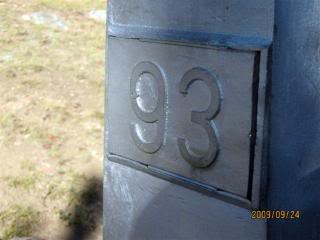
At 2:30 we had a night visitor. The young wolf called and barked for a long time as if calling Shanty who seemed little more than intrigued. Finally, the wolf moved off and we were able to get a few more hours of sleep.
We were up and eating before the early sunlight. Issy was more interested in smelling all the droppings than grazing, so I saddled up and rode down the trail heading toward Spanish Cabin. At Andrew’s Pass Issy started to pull as he did when he knew he was heading home so I let him set the pace. Within 7 hours we were at camp telling Burton all about Monument 93 and the wolf.