May 1 - Port and I rested.
May 2
This morning Port was full of life, pawing for breakfast and seeming fine. 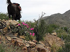 I decided to pad his heels and put the lighter boots back on. This is no easy job. The boots are snug to start with and adding duct tape on top of padded heels made getting them on close to impossible. Finally, after both of us were worn out, the boots were on and we headed for the trail. Port was still in good spirits gently nosing me at almost every step. I first noticed this odd behavior from him miles ago, thinking he was about to step on the back of my legs by getting so close. While my initial instinct was to turn and reprimand him, I was fortunate enough to see his shadow and notice that it looked very strange. He would gently reach out and touch my back with his nose then just walk on. He seemed to do this whenever we were ledge walking. (Remember I still can’t ride those ledges on horse back – just too terrifying.)
I was very glad I didn’t overreact to his first gesture. Seeing his shadow let me know it wasn’t a rude action. I’m not sure what it means but will pay attention over the next few hundred miles and see if I can understand. We left Scissors Crossing and headed north to Barrel Springs following along the San Felipe Hills watching the valley below. I was still leading Port. The flowers were stunning again  and we looked forward to arriving at our destination as it has the only reliable water on this section. Because today's leg of our trip is a dry 23 miles, we carried horse water in addition to our own. At 8 pounds per gallon we were weighted pretty heavy.
 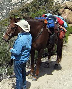 I packed only 3 gallons, just enough for a throat clearing at mid day. We climbed and circled the mountain so many times I thought I was going around on the same path. Seeing the same scenery over and over made me wonder if we were actually going anywhere. Soon the ledges became old hat and I even rode a few uphill (up mountain, rather). All of a sudden I realized I no longer was terrified, only getting sweaty palms when the footing gave way under Port’s weight. The sandy rock ledge would sometimes just disappear down the mountain and Port would move forward for an instant on three feet. Several times he would lunge forward to pull both of us up with his front feet, and I said a quick prayer.
Port’s feet seemed to be okay and he was getting more powerful every mile. What a working machine, only when he is dehydrated do I notice any change in pace. He is some horse! I guess the change in the attachment of the boots was the problem, one kind uses more wraps around his pastern while the other just grabs his heels below the coronet band. We pulled up to Barrel Springs only to find the tank had a sign on it stating the water is contaminated. We were as dehydrated as can be and that sign was a real blow. No water is very serious! Luckily we were being picked up by Burton on Montezuma Valley Rd and taken to a “real camp with all the goodies like water and electricity. So within the hour Port would have all the water he wanted.  Later I read that the water direct from the pipe at the tank was fine. That would have meant a lot to anyone who had to continue on the trail without support. I realized that my research wasn’t as meticulous as the initial trail research was. I better get back on task and hammer down the details like before.
May 3,
Last night was a real treat - I had a shower with lots of hot water. Burton went shopping getting us ham, asparagus, jalapeno bread, cream cheese and bagels. I washed clothes and Port relaxed in a large covered pen with other horses in close proximity. Stagecoach Campgrounds was a perfect respite from the unknown of the trails. The schedule was to head out from Barrel Springs to Warner Springs as soon as we could get going. By 7 we were on the trail again, refreshed and looking forward to the new challenges the trail would throw at us.  We climbed out of the valley, and I was riding Port feeling his power pull me up the mountain (yes, along the narrow ledge). I looked back trying to see if I could make out our rig but Burton was gone.
 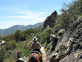 Today’s ride passed through Warner Springs and on to Indian Flats. Warner Springs sits just outside the Los Coyotes Indian Reservation at the Aguanga geological fault, home to hot springs that produce 230,000gallons of 138 degree water every day.
 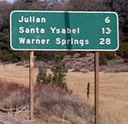 Warner Springs, acquired by Jonathan Warner of Connecticut (I can spell Connecticut because I grew up there.), were the site of a stop for the Butterfield Stage and later became a resort. Traveling toward Warner Springs was a real treat. The terrain is very horse friendly and we trotted then cantered like little kids riding away on a summer day. Only an occasional hiker slowed us so we didn’t cause them to worry about this 1200 pound freight train rolling by. About half way to Warner is the implausible Eagle Rock.
 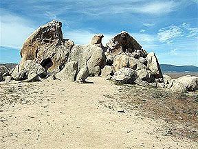 Standing there looking at Eagle Rock I realized how much Nature has done to keep all of us entertained. This incredible rock formation stands as an eagle overlooking the valley and I got a feeling he protects it as well. After taking photos
 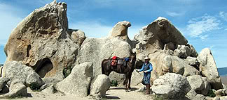 we hoofed on and reached a hiker with a 16 week old puppy, one of those cross bred toy gimmicks which was actually pretty cute. “Anza” came running to play with the BIG “dog” and Port just put his nose to her and they both froze for an instant. I panicked that “Anza” would become stomped stew, and her owner beckoned her away. Her owner turned out to be a family physician from Vancouver CAN, here with her husband while he does some research. She is a delightful lady who promptly invited us to stay at her place when we get to Canada, offering to make arrangements for Port as well. Boy, I love such positive thinking. Exchanging addresses, we parted new friends, and I think we both would have loved more time to chat. The trail became draped with trees ushering us towards Warner Springs. The cool canopy following the Canada Verde Creek (that’s a coincidence) made the trail seem like a well manicured bridle path on the east coast. And then we were there, right out on Hwy 79 with traffic flying by. The PCT trail marker shows the route going under 79
  using an underpass barely tall enough for Anza but not much else. So we crossed the asphalt between fire trucks, golf carts and hurrying motorists. On the other side of 79 was an immediate reprieve, open fields and lulling trail heading toward a creek bottom lined with trees. It was as if Hwy 79 never was as the traffic sounds quickly faded away. It was a good thing my attention was forward because we rode right up on a band of horses. These aren’t wild, but are free to roam hundreds of acres with no fences.
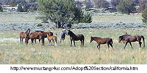
The very nature of this vast freedom brings out the wild nature in a domesticated horse. I was sure there was a stallion who wanted to enforce his band territory. I thought maybe I should dismount, then thought better of it knowing I was probably safer on Port’s back. Port is basically a coward when it comes to stallions and he would probably run like the wind with me hanging on for dear life if a stallion approached. We moved forward knowing the trail passed right along side of the herd. I saw the gate just on the other side of the herd. I watched for the first signs of alarm, but only one paint raised his head (the stallion or top mare?) and no alerts were sounded. The herd (there were at least 50 horses) remained calm and kept grazing. We proceeded with utmost caution. Port was tense, ears switching, but he kept his head down, an interesting change since he almost always greets other horses with his head high and tail flagged. Maybe Port’s demeanor was horse language that we were no threat to the herd. Whatever the dynamics of his actions meant to the herd I was amazed that we passed totally without incident. Getting to the gate I dismounted and hurried us through. I noticed that the paint was still eying us, and I realized that I had just experienced a lesson in horse behavior that few get to experience first hand. I’m sure I’ll replay that encounter over and over dissecting it to glean every bit of knowledge I can. How fortunate I am. But, the day is only half over. We still have to get to Indian Flats.
I would like to mention that I started the day riding in my hunting saddle which I had modified for this trip.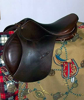
It only weighs 12 pounds I thought it would be an advantage to save the 15 pounds more that my western saddle 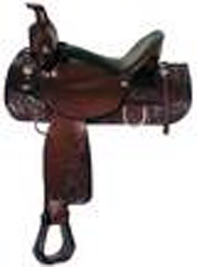 weighs. Big mistake! The saddle, a very well padded and comfortable saddle for 2 or 3 hours, places me in a forward position.
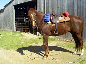
There is basically no way to sit upright and straight as I would in my good western saddle. My whole body was sore from being in this forward position and I was looking for a way out of that misery. I tried lowering my stirrups, raising them, tried arching my back, tried sitting full seat in the saddle (which I never do) and nothing worked. This saddle will be shipped back home at the first opportunity. Agony!
We moved forward and came upon a group of camping Boy Scouts. I asked if there was any water for Port who was very thirsty. They pointed out a faucet and I filled Port’s canvas bucket twice for him to drink. The Boy Scouts were intrigued with our plans and came over to talk. One red-headed freckled-face fellow reached out to Port’s nose and gently rubbed it. Ah, a horse lover! I was in my element now. I loosened Port’s girth so he knew we would be spending a few minutes there. I looked for a way to engage the boys. Talking about Eagle Rock, then the horses we exchanged stories. I got a chance to enlighten them about the wondrous world of horse ownership. Maybe “Red” will go home with the desire to explore it.
We moved off heading to Indian Flats with a bit of a climb ahead of us with an elevation increase of over 1,000 feet. Along the way, we pass a hiker who is really traveling “Chuck” is the strongest hiker we have seen and we must let him pass as he motors up Pine Mountain. The trail is narrow (one of those ledge ones I love so much) and we cautiously picked each step. After several hours we finally started looking for Burton and the rig down on the ridge road since the trailhead was only a mile or two ahead. Burton has been good at getting right up to the trail,
and the sight of the rig is welcome (remember my fanny and other unmentionables being at odds with this saddle.) We longingly looked at the trailer sitting down there and realized we had a few more miles to go before the trail dropped back to the trailhead. Oh boy! More ledge riding! Passing along a canyon wall and hanging there by sheer gravity, we heard gun shots that echoed against the canyon wall making it sound as if we were being shot at. I quickly dismounted and we walked precariously on the ledge. Shots again! Good grief, don’t they know they are frightening both horse and rider? I finally screamed out asking them to please stop shooting. One clod answered back “we were here first” Can you believe this? The safety of a person and a horse was at risk and that was their response? I screamed out that we were just trying to get to the trailer and down off the mountain, leaving it to them (and their illegal shooting.). They did stop, and we circled and switched back and forth down to the trailer, loaded up and headed down.
Now all this time I thought I was having the adventure. But, no!! Burton informs me that I am assigned to road stability detail. I soon found out that the road was so very narrow that the trailer and sometimes the wheels of the truck hover over the cliffs and travel in mid air to make turns around rock faces sticking out. Burton took hours to go these 5 miles, literally hours, even with a couple helping him make the turns, so he could keep his commitment to us and be at the trail head. Now, I was assigned to walk on the –yes, you guessed it – the edge of the cliff and be sure the wheels of the truck and trailer were at least partly on solid ground. You all know how I loved that job…. I offered to unload Port and walk him down. No, that wouldn’t play – we had to get the trailer down. So we started down, winding and bending.
For 5 miles I helped ease the tires back to safety while behind us is “Motoring Chuck” and Annie who was waiting for him beyond the trailer. They patiently followed as we crept along, Chuck telling us how he loves horses and didn’t mind taking hours going 5 miles. Finally, we arrived at the base of the mountain. With thumbs up we parted with Chuck and Annie. Burton told me that this was just about like all the other routes he has made to meet us. I guess I have been so tired I never realized he was working through so many things on my behalf. We went back to Stagecoach Campground and relaxed another night.
May 4
Today the goal was Tule Canyon Road which is only 17 miles from Indian Flats, but we added 5 miles as we road walked the 5 miles back to the trailhead. None of us wanted to go through the horse trailer over the cliff scenario a second time. Water was again a big concern, with no water anywhere along this section of the trail. As we climbed to higher altitude we passed through saddles so narrow I thought the trail could fall off of either side. 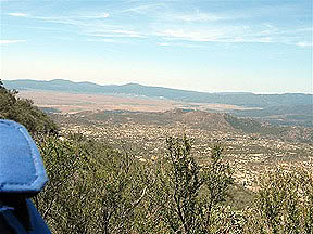
That kept us moving and feeling that if we even moved our heads to look at the views we might go crashing down one of the endless ravines. After a few miles we approached a side trail with a sign that read “water .2 miles”. We decided to check out the spring and were glad we did. Lost Spring was a delightful tree shaded area with cold, fresh spring water that proved a refreshing stop. Knowing the trail was long we pushed on, winding and turning along the mountain face to arrive at Chihuahua Valley Road (5050 elevation) and who was there? Motoring Chuck and Annie, both taking a break before Chuck was to hike on to Combs Peak at 6193 elevation. Annie had brought Chuck’s resupply. (I would like to know what she put in HIS water since he continues to climb those grades like he was walking on Fifth Avenue, New York.) We parted company going to Mike Herrera’s where Mike has a source of water for PCT travelers.It is only a short distance from the PCT along Chihuahua Valley Road. We found a large holding tank
with a spigot and, oddly, New Age Music blaring from Mike’s house. The music had Port on edge but his thirst was stronger than his desire to leave, and we both got our fill.
Back to the base of Bucksnort Mountain we proceeded north on the PCT hoping to get to Tule Canyon Road before dark. Estimating the time it takes to travel each mile is difficult because of the elevation changes and the path the trail takes around the mountain. What may have looked like a short distance could take a very long time as we breathlessly climbed upward.
Every day there is something different about the trail. Most days there isn’t a chance to do more than walk and lead Port since the trail is narrow and steep. Occasionally there is a little reprieve, and I can mount up and move out. These are always welcome stretches. We passed Combs Peak and continued on. I watched as the sun got lower and lower, thinking that this trail was no place to be in the dark. Walking the trail on foot after dark was possible, but to traverse it safely with a horse I would want to have a huge light. Since I had only one of those Shaker Lights which give off minimal light, it was imperative that we hurry.
With several miles behind us from Chihuahua Valley Road I started to look for Burton. Far off (I mean VERY far off) I saw the rig. It looked like a spec on the remote mountain, it must have been at least 5 miles farther.
The road I was watching was the wrong one. It didn’t even go through to the rig, so I was left with nothing else to do but to push on and hope we beat sunset.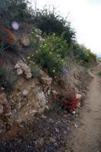
Exhaustion enveloped both of us so much I was walking and Port was just plodding along. Trying to hurry him was futile, he was spent! There was no option other than to trudge on. Finally after watching the spec of a rig grow in surreal time, we got to a road which was clearly a through road. But, it was behind a locked gate. I pulled out my map and saw that we were at the edge of Sheep Canyon Wilderness. No, this wasn’t our road. We still had several miles to go. The sun had set, but mercifully the desert still reflected the light. We found a higher gear, moving along much faster. Port always seems to know when we are close to the trailer. Maybe he sees it, hears it or just “senses” it, but he quickened his pace.
Then we were stopped by a middle aged fellow who said he had to go back to his hurt friend. (I was just too tired to go back to help, and I knew Port would be in danger if I forced him to carry someone for very long). I asked if there was anything I could do. The fellow said that the gate at Tule Canyon Road might be closed and that they would need to get it opened so they could get his friend out. Getting that gate open I could take care of. . Agreeing to do what ever it took to get the gate open, I parted with the knowledge that Tule Canyon Road must be close. In a mile or so I came upon Tule Canyon Truck Road…Was this the same road? We just couldn’t make a mistake now as exhausted as we were. I pulled out my map to verify that Tule Canyon Road was the only road. I remembered there was that road to nowhere which was not on any of my maps, so I don’t feel very confident, but decided that this road was the one I needed. Since we were in a canyon I could no longer see the rig to confirm our route. But Port was starting to pull so I trusted him. Within 30 minutes we get to a Forest Service gate which appeared locked. Luckily it wasn’t. Opening it was simple (My promise to the fellow was kept) and I thought we must be on the right road. Finally, we saw the rig and almost collapsed into it. On our way out I found it incredible that Burton has once again been able to find his way to this trail.
May 5,
Today we were to get to Hwy 74, only a short 14 miles. Hwy 74 is the start of the San Bernardino National Forest and the gateway to the infamous Fuller Ridge. 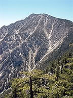 Burton dropped us off back at Tule Canyon “Truck” Road and we moved out thinking that our day would be easy and light even thought we were starting at 3650’ elevation and climbing to 4919’ going into Nance Canyon and then up Table Mountain. Now I look at the maps as they really are, with elevation being as important as the route itself. That lesson only took 151 miles to learn.
Putting all available information together I figured we should get to Hwy 74 in a little over 7 hours. When I was riding Port at home we averaged 4+ miles per hour at a walk. With the rugged terrain and changing elevation I must constantly reevaluate our timing for this trail. One thing for sure - I am riding a powerhouse of a horse. Port’s fitness level is way beyond what I could have thought possible. He has muscles bulging everywhere.
I am riding bitless so Port can graze easily. 
I really don’t want to get into a fight with him, as he would surely win. But Port is a kind, sensitive soul who listens and eagerly moves on my commands.  What a privilege to ride such a grand horse.
Heading over Table Mountain we cross Alkali Wash which was a vast ravine with no vegetation or any kind. It dropped off Table Mountain with such a vengeance that I felt like it was pulling us over the cliff and into infinity. We hurried over the saddle at the head of Table Mountain and turned north to face Lookout Mountain. We skirted Lookout Mountain’s 5590’ elevation on its west side. The vegetation here is funny. The western side of the mountains catches the Pacific rains and is relatively lush with vegetation. The eastern side of the mountains is dry and desert like. We could see Hwy 74 and yes, there was Burton waiting as usual. This time he had a blacktop road and real pull off to wait for us. He had 2 buckets of water and Port emptied both. We loaded up both horses and dropped off Janice and Jur at their camp.
(Note: Ralph, Janice's husband had an emotional breakdown, was discourtious to our next layover stop and even made verbal threats to the caretaker there. Ralph saw the world from a very sad perspective and daily had drama about one thing or another, keeping Burton and I always upset, never knowing what was next and not ever being able to count on him. Even little things would cause Ralph to act strangely and Burton and I decided that we needed to split company from him as we didn't want to be associated with anything negative towards equestrians, part of our agenda was to build horse owners awareness as well as tolerance for horses on the trail and Ralph's continuous bizarre behavior was counter to that objective. We would continue and I would ride alone. This made for a much more relaxed camp with peace and tranquillity being our companions.)
Tonight Burton took us to McCall Park to rest. McCall Memorial Park is one of the cleanest horse camps I have ever seen. Although they don’t have any hookups, the horse pens are spotless. The location is between two mountains with the valley below all lit up. At McCall the host and hostess are great people. They introduce themselves and he is a “Barefoot Farrier” Yes, sir….a barefoot farrier. And, I don’t mean HE goes barefoot. I sit and discuss Port’s feet which are now perfect and hard as rocks. I felt good meeting someone who thinks like I do about no metal shoes. He has kept his mountain horses barefoot for years and their feet looked great. 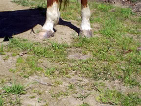
Some of my guilt about not having Port shod subsides, and I know that Port will continue to be fine going barefoot with a little help from his boots.
We discussed Fuller Ridge, a very serious section of the PCT where several people have died by getting lost or falling. I was already warned not to try Fuller Ridge by a horseman who completed the entire PCT southern section, but I was not convinced that it could be as bad as everyone says. So Danny called a 90 year old horseman, Sam, who just attempted to ride the Fuller Ridge portion of the trail but turned back at the “Hog’s Back” south of Tahquitz Peak. Since Sam was just on the trail this past weekend, I felt I was getting current and precise information. Sam said don’t do it! Fuller Ridge was impassible to horses. There were trees down along the ledge, snow still covered the trail and people were postholing (a term used to describe a person just dropping out of sight right there on the trail because of the deep snow.) Can you imagine trying to dig out a horse in that? Okay, I am now a believer that I should not take my horse along Fuller Ridge. So we plan to load up and bypass this 50+ mile section and start on the other side of the mountain in the morning.